Africa is one of the continents most affected by disasters triggered by natural hazards. The result of climate change is a reality that affects every human being, whether it is extreme heat waves, cyclones, or the devastation of drought and floods. Climate change can provoke injuries or fatalities and affects the livelihoods of people in both rural communities and urban areas. It triggers damage and losses in various sectors of development, such as housing, road infrastructure, agriculture, health, education, telecommunications, energy, and affects routine economic processes leading to economic losses.
According to Dr Dumitru Dorin Prunariu, President of the Association of Space Explorers Europe, space programmes have become an important force defining challenges of the 21st century. “Space observation is essential for climate-change monitoring,” he said.
Dr Prunariu was the keynote speaker at a two-day symposium on climate resilience and water that was hosted by the Disaster Management Training and Education Centre for Africa (DiMTEC), at the University of the Free State (UFS). He participated in the Soviet Union’s Intercosmos programme and completed an eight day-mission on board Soyuz 40 and the Salyut 6 space laboratory, where he and fellow cosmonaut Leonid Popov completed scientific experiments in the fields of astrophysics, space radiation, space technology, space medicine, and biology. He is the 103rd human being to have travelled to outer space.
The focus of Dr Prunariu’s lecture was: Space activities in support of climate change mitigation and climate resilience.
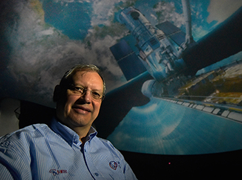
Dr Dumitru Dorin Prunariu, the 103rd human
being in outer space and President of
the Association of Space Explorers Europe.
Photo: Charl Devenish
Space-based information, an extra eye that can detect a way out during disasters
“For governments to support communities affected by any disaster, precise and up-to-date information on its impacts is essential as a way to respond in a timely and effective way,” said Dr Prunariu.
Space-based information (derived using Earth observation, global navigation satellite systems, and satellite communications) can play a vital role in supporting disaster-risk reduction, response, and recovery efforts, by providing accurate and timely information to decision-makers.
“With space-based information, disaster management teams will be able to take note of recently established roads that may not appear in typical maps produced by National Geographic Institutes, but which could be used as emergency evacuation routes or as roads to deliver humanitarian assistance to those who require it in remote areas."
Space-based tools help decision-makers to improve planning
“Space-based tools and spatial data infrastructure is also crucial for policy planners and decision-makers in increasing the resilience of human settlements. Using geographic data and information collected before the occurrence of major disasters in combination with post-disaster data could yield important ideas for improved urban planning, especially in disaster-prone areas and highly-populated regions.
“In the recovery process, information on impact is used by governments to provide assistance to those affected, to plan the reconstruction process, and to restore the livelihoods of those affected,” said Dr Prunariu.
“Space observation is
essential for climate-
change monitoring.”
The symposium was attended by representatives from Liberia, Nigeria, Kenya, Ghana, Namibia, and Zimbabwe, with various international scientists from Europe imparting their expert knowledge on water and global resilience. The presence of these international experts strengthened global networks.
It isn't important in which sea or lake you observe a slick of pollution, or in the forests of which country a fire breaks out, or on which continent a hurricane arises, you are standing guard over the whole of our Earth. - Yuri Artyukhin: Soviet Russian cosmonaut and engineer who made a single flight into space.