#Women'sMonth: Long hours in wind and cold weather help to reconstruct Marion Island’s glacial history
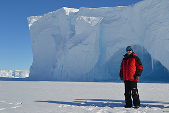
Liezel Rudolph, lecturer for second-year students in Process
Geomorphology at the University of the Free State (UFS).
Photo: RA Dwight
Liezel Rudolph, a lecturer for second-year students in Process Geomorphology, aims to reconstruct the glacial history of Marion Island through cosmogenic nuclide dating techniques. She is interested in periglacial geomorphology, a study of how the earth’s surface could be formed by ice actions (freezing and thawing of ice).
Liezel is a lecturer in the Department of Geography at the university and is researching landscape development specifically in cold environments such as Antarctica, the Sub-Antarctic islands, and high mountain areas. “My involvement with periglacial geomorphology is largely due to academic giants who have carved a pathway for South Africans,” says Liezel.
Liezel visited Marion Island for the first time during her honours year in 2011, when she investigated the impact of seals on soil conditions and vegetation. Three years later, she visited Antarctica to study rock glaciers.
The challenge of the job
A workday in Antarctica is challenging. “Our time in the field is very limited, so you have to work every possible hour when the weather is not life-threatening: from collecting soil samples, to measuring soil temperature and downloading data, we measure polygons and test the hardness of rocks. The only way to get the amount of work done, is to work long hours in wind and rain with a positive and competent team! We take turns with chores: the person carrying the notebook is usually the coldest, while the rest of us are stretching acrobatically over rocks to get every nook and cranny measured and documented.”
A typical workday
Liezel describes a typical workday: “Your day starts with a stiff breakfast (bacon and eggs and a bowl of oats) and great coffee! After that comes the twenty-minute dressing session: first a tight-fitting under-layer, a middle layer – sweater and T-shirt, and then the outer windbreaker (or a quilt jacket on an extra cold day). Then you start applying sunscreen to every bit of open face area. Beanie on, sunglasses, two pairs of socks, two pairs of gloves. The few kilograms of equipment, one vacuum flask containing an energy drink, one vacuum flask containing drinking water (it would freeze in a regular bottle), and a chocolate bar and piece of biltong for lunch. After this, we drive (on snowmobiles) or fly (in helicopter) to our study area for about eight hours of digging, measuring, downloading, testing and chopping. Back at the base and after a long and tiresome undressing session, we move to the lab with all our data to make sure that it is downloaded safely and captured onto a database. Afterwards, depending on the day of the week, we enjoy a good meal. If you are lucky, such a typical day will coincide with your shower day. We can only shower every second day due to the energy-intensive water production (we have to melt snow) and the sewage system (all the water has to be purified before it could be returned to the environment). Then you grab your eye shield (since the sun is not sinking during summer) and take a nap before the sun continues to shine into the next day.”
Theoretical knowledge broadened
“Going into the field (whether island or mountains) provides me with an opportunity to test geomorphic theories. Without experience in the field, my knowledge will only be limited to book knowledge. With practical experience, I hope to broaden my knowledge so that I could train my students from experience rather than from a textbook,” says Liezel.