Latest News Archive

Please select Category, Year, and then Month to display items
Previous Archive
25 May 2020 | Story Dr Ralph Clark | Photo Charl Devenish
Afromontane research area in the Eastern Free State.

Africa could be called ‘the continent of mountain archipelagos’ for the unusual fact that most of Africa's mountains are isolated ‘islands’ rather than linear, continuous mountain systems such as those in Asia (e.g. the Himalayas), Europe (e.g. the Alps), and the Americas (e.g. Rockies and Andes). Even in Southern Africa, where we have the linear Great Escarpment (5 000 km long), this system is so old that it has been breached in innumerable places by erosion into a series of independent mountain blocks.

The result of this mountain disconnection is that Africa's mountains display biodiversity patterns more akin to islands than to mountains: rich, exciting, and unique, and full of very localised and interesting species. Likewise, mountain communities have established and evolved unique cultural ways of life and traditions in their particular mountains – isolated from other groups on other mountains. But in some mountains, internecine warfare and tribal conflict caused mountains to become boundaries rather than welcoming places. This was certainly the case during the Mfecane in Southern Africa, ultimately leading to the birth of Lesotho as the ‘Mountain Kingdom’. Colonialism took this to a new level, and – for most of Africa – mountains became international borders between empires, splitting ethnic groups into several nationalities and marginalising large segments of the population in these new countries. This same geopolitical situation continues today, with major implications for the sustainable management of mountain ecosystem services, natural capital, and socio-cultural sustainability in multinational contexts.

The Afromontane Research Unit (ARU) – a continental leader in African mountain research – seeks to explore these socio-ecological complexities in terms of sustainable development, providing research that can help to secure a positive future for the people, biodiversity, and goods and services provided by Africa's mountains. As part of its mission, the ARU is leading the way in encouraging a multidisciplinary community of practice that will drive a science-policy-action interface for Southern African mountains in decades to come. As virtually all of Africa's water comes from its mountains, this is a critical service to a region increasingly at risk from drought and the socio-political implications of rivers and taps running dry. 

Although the Qwaqwa Campus is the home of the ARU, the ARU is welcoming affiliations from across the UFS and beyond. Should you wish to become affiliated to the ARU, please contact the Director, Dr Ralph Clark at ClarkVR@ufs.ac.za. Visit the new ARU's website 

News Archive

Unconventional oil and gas extraction – study for Water Research Commission reveals possible impacts
2014-11-05


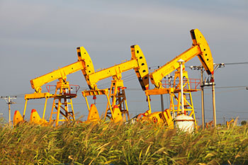
Photo: Legalplanet.org
The Centre for Environmental Management (CEM) at the University of the Free State (UFS) recently completed a three-year project for the Water Research Commission. The purpose was to develop an interactive vulnerability map and monitoring framework for unconventional oil and gas extraction (final report still to be published).

Due to the complexity of this field, a number of participants across different disciplines and universities were involved in this trans-disciplinary study. Contributors included the Departments of Sociology, Physics and Mathematical Statistics from the UFS, the University of Pretoria Natural Hazard Centre, Africa, as well as the Institute of Marine and Environmental Law from the University of Cape Town.

Unconventional oil and gas extraction, its related impacts and the management of this activity to ensure environmental protection, is a controversial issue in many countries worldwide. Since the extraction of oil and gas using unconventional techniques is an unprecedented activity in South Africa, the project focused on understanding this extraction process as well as hydraulic fracturing and identifying possible environmental and socio-economic impacts associated with this activity in the South African context. An understanding of the possible impacts could aid government during the development of policy aimed at protecting the environment.

The researchers subsequently identified indicators to develop an interactive vulnerability map for unconventional oil and gas in South Africa. The vulnerability map focuses on specific mapping themes, which include surface water, groundwater, vegetation, seismicity and socio-economics. In addition, the map provides information on the vulnerability of the specified mapping themes to unconventional gas extraction on a regional scale. This map is intended as a reconnaissance tool to inform decision-makers on areas where additional detail field work and assessments may be required. It can also be used during Environmental Impact Assessments and determining licensing conditions.

Lastly, a monitoring framework was developed, which describes monitoring requirements for specific entities – surface water, groundwater, vegetation, seismicity and socio-economics – for the different phases of unconventional oil and gas extraction. Such monitoring is an important part of environmental protection. It is especially important for South Africa to perform baseline monitoring before exploration starts to ensure that we will have reference conditions to identify what impact oil and gas extraction activities has on the biophysical and socio-economic environments.


We use cookies to make interactions with our websites and services easy and meaningful. To better understand how they are used, read more about the UFS cookie policy. By continuing to use this site you are giving us your consent to do this.

Accept