Latest News Archive

Please select Category, Year, and then Month to display items
Previous Archive
21 April 2023 | Story Leonie Bolleurs | Photo Supplied
Dr Katlego Mashiane
Striving to make a difference in the field of biodiversity conservation, Dr Katlego Mashiane decided to pursue a PhD in Geography, focusing on the spatial modelling of grassland diversity and nutrients in subalpine environments. He received his PhD during the recent April graduation ceremonies on the Qwaqwa Campus.

In the small village of Ga-Mabotia about 25 km outside of Polokwane, Dr Katlego Mashiane grew up, surrounded by rocky mountains characterised by boulder outcrops, where he interacted with nature from an early age. 

He recently obtained his PhD, majoring in Geography, from the University of the Free State (UFS), which was conferred on him during the April graduation ceremonies that took place on the UFS Qwaqwa Campus. The title of his dissertation is Grass nutrients estimation as an Indicator of rangeland quality using satellite remote.

Predicting the presence of biodiversity and nutrients in an area

Based on the principle that diverse grasslands tend to perform better, environmental changes threaten the resilience and services these grassland ecosystems provide. The study examined how many different types of plants and animals can be found at a particular place to enhance our understanding of the ecosystem’s value to humans, and that biodiversity loss will reduce these ecosystem services. Focusing on spatial modelling of grassland diversity, Dr Mashiane specifically investigated the influence of topography and remotely sensed satellite data on species richness and diversity in subalpine environments, and how they are affected by the availability of grass species. To determine this, he used a random forest machine-learning algorithm to find the best information in the data that could be used to estimate the levels of species richness, diversity, and nitrogen in a protected national conservation park. 

His study discovered that some data types – such as the near-infrared variable and certain vegetation data (EVI and SAVI) – were especially useful for determining the number and variety of species in a certain area. With this information, scientists can create models that predict the presence of different types of biodiversity and nutrients in an area.

Playing a key role in protecting our natural assets

Equipped with this knowledge, one will be able to understand how to protect and preserve different types of biodiversity and promote the nutritional value of both plants and animals in the environment. “Land managers could use this information for conservation strategies,” states Dr Mashiane, who decided to pursue this study because he was curious about how environmental changes will affect species.

“Grasslands provide important ecosystem services underpinning human well-being, and therefore warrant our protection; I would like to play a role in protecting our natural assets and contribute to understanding our biomes, especially in the context of global change,” he says.

In the next five years, Dr Mashiane plans to pursue further research and mentor other students in his field of study.

News Archive

UFS enhances Geography in schools
2015-05-11

The Green Box

The Department of Geography at the University of the Free State (UFS), in association with the Society of South African Geographers (SSAG), is doing their part in providing curriculum support to schools. Dr Ruth Massey and Anneri Pretorius are the project managers of Green Box, an initiative to advance Geography in schools.

The Green Box supports the intermediate phase of schooling (Grades 4, 5, 6). According to Dr Massey, the worksheets and activities provided in the Green Box are aligned with the Curriculum and Assessment Policy Statements (CAPS) and the new curriculum. “These worksheets are divided into three themes: map work, physical Geography, and human Geography.

“Map work includes symbols and keys, grid references, and compass work whilst physical Geography focuses on water and waste, biodiversity and conservation, and weather and climate issues. The human Geography theme has a focus on population, rural and urban development, migration, food and farming, and transport and trade,” she said.

Each worksheet has a fact sheet section which teaches theory on the specific topic (linked to the curriculum), an activity section (all resources needed for these activities are provided in the box), and a ‘take it home’ section for further learning and practice at home.

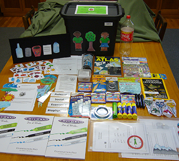
The Green Box is a recycled plastic crate that comprises worksheets, training materials, visual aids, and resources for teaching, learning, and active engagement in Geography classes.

Also included in the box are a felt story board and characters (that link with the worksheet activities), the ‘Climate Change memory game’ (which enhances learner’s memory capabilities and teaches various climate change facts) and the ‘Sustainable Development puzzle game’ (which teaches about the social, biophysical, economic, and political elements of Sustainable Development, and how they overlap).

“All items in the box are locally sourced, robust, and without copyright,” said Dr Massey.

The project is focusing on 10 under-resourced schools in the Bloemfontein area. Each school has received three boxes (one for each grade of the Intermediate Phase).

Dr Massey said: “This box is to be shared among the teachers. The Green Boxes were distributed at a training and information workshop held at three central schools in the various districts. These workshops introduced the teachers to the contents of their box, and provided basic training on the worksheets and the activities provided.”

“The schools will be joined up with ‘Box Buddies’ at more resourced schools in Bloemfontein. These buddy schools will assist in support and in replenishing the box’s stationery, etc. when needed.”

“Monitoring and evaluation will take place for six months after the boxes have been distributed. This will ensure support to, and the sustainability of, the project.” The Green Box project was made possible through a grant from the Society of South African Geographers (SSAG).

We use cookies to make interactions with our websites and services easy and meaningful. To better understand how they are used, read more about the UFS cookie policy. By continuing to use this site you are giving us your consent to do this.

Accept