Latest News Archive

Please select Category, Year, and then Month to display items
Previous Archive
08 February 2024 | Story Lunga Luthuli | Photo SUPPLIED
Student Campus Tour
The UFS Division of Student Affairs is helping first-time students get their bearings by offering campus tours on the Bloemfontein, South, and Qwaqwa campuses.

The University of the Free State’s (UFS’s) Division of Student Affairs is ready to welcome 2024’s first-time entering students (FTENS) for the new academic year with an engaging campus tour. 

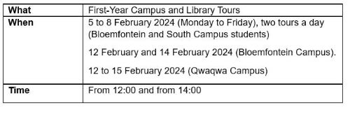
These tours will take place on the Bloemfontein and South Campuses from 5 to 8 February starting at 12:00, and on the Qwaqwa Campus from 12 to 15 February, with one tour daily, from 14:00. Students must note that the 5 to 8 February schedule aligns with specific colleges each day, which means you should attend on the day specified below for students from your college.

The comprehensive tour route covers vital campus locations, including Protection Services, the Administration buildings, examination venues, Kovsie Health, Student Counselling and Development, Arts and Culture, Callie Human, HMS, Main Building, and many more. The itinerary helps students become familiar with significant facilities on the three UFS campuses.

The Division of Student Affairs aims to make the campus tours even more inclusive by allowing commuter students and late registrants to join a later group of tours, on 12 and 14 February on the Bloemfontein Campus.

Campus Tours

Tour guide

ROUTE: 


Main locations: 

Bloemfontein Campus:
Meet at the Kovsie Village (i.e. the tent next to the EXR registration venue)-> Protection Services (Stopping Point) -> George du Toit -> EXR -> Kovsie Health; SCD; Food Environment Office; Arts and Culture -> Callie Human -> HMS -> Main Building -> ECLA Lab -> Vishuis -> 24-hour study labs -> Stabilis -> Bridge (Bank; Van Schaik) -> FGG -> EBW -> Landbou; Visitors Gate-> Kopanong; Genmin Lectorium -> Computer Lab -> Mabaleng Auditorium -> Winkie Direko (Fundza Offices) -> Ned Education Building -> Modlec; Konica Minolta -> Library (organise in faculty).


South Campus Tour:

Dates: 6 and 8 February 2024
Time: 12:00 
Starting point: Amphitheatre (Outside the cafeteria)

Qwaqwa Campus Tour:

Date: 12 February 2024             
Time: 14:00 (Faculty of Economic and Management Sciences)
Assembly point: Amphitheatre

Date: 13 February 2024             
First time slot: 14:00 (Faculty of Natural and Agricultural Sciences)
Assembly point: Amphitheatre

Date: 14 February 2024
First time slot: 14:00 (Faculty of Education)
Assembly point: Amphitheatre

Date: 15 February 2024             
First time slot: 14:00 (Faculty of the Humanities)
Assembly point: Amphitheatre

Qwaqwa Off Campus Tour

Date: 18 February 2024
Time: 08:00
Assembly point: Amphitheatre

To register for the campus tours, please click here

News Archive

Water erosion research help determine future of dams
2017-03-07

Description: Dr Jay le Roux Tags: Dr Jay le Roux

Dr Jay le Roux, one of 31 new NRF-rated
researchers at the University of the Free State,
aims for a higher rating from the NRF.
Photo: Rulanzen Martin

“This rating will motivate me to do more research, to improve outcomes, and to aim for a higher C-rating.” This was the response of Dr Jay le Roux, who was recently graded as an Y2-rated researcher by the National Research Foundation (NRF).

Dr Le Roux, senior lecturer in the Department of Geography at the University of the Free State (UFS), is one of 31 new NRF-rated researchers at the UFS. “This grading will make it possible to focus on more specific research during field research and to come in contact with other experts. Researchers are graded on their potential or contribution in their respective fields,” he said.

Research assess different techniques
His research on water erosion risk in South Africa (SA) is a methodological framework with three hierarchal levels presented. It was done in collaboration with the University of Pretoria (UP), Water Research Commission, Department of Agriculture, Forestry and Fisheries, and recently Rhodes University and the Department of Environmental Affairs. Dr Le Roux was registered for 5 years at UP, while working full-time for the Agricultural Research Council – Institute for Soil, Climate and Water (ARC-ISCW).

Water erosion risk assessment in South Africa: towards a methodological framework
, illustrates the most feasible erosion assessment techniques and input datasets that can be used to map water erosion features in SA. It also emphasises the simplicity required for application at a regional scale, with proper incorporation of the most important erosion-causal factors.

The main feature that distinguishes this approach from previous studies is the fact that this study interprets erosion features as individual sediment sources. Modelling the sediment yield contribution from gully erosion (also known as dongas) with emphasis on connectivity and sediment transport, can be considered as an important step towards the assessment of sediment produce at regional scale. 
 
Dams a pivotal element in river networks

Soil is an important, but limited natural resource in SA. Soil erosion not only involves loss of fertile topsoil and reduction of soil productivity, but is also coupled with serious off-site impacts related to increased mobilisation of sediment and delivery to rivers.

The siltation of dams is a big problem in SA, especially dams that are located in eroded catchment areas. Dr Le Roux recently developed a model to assess sediment yield contribution from gully erosion at a large catchment scale. “The Mzimvubu River Catchment is the only large river network in SA on record without a dam.” The flow and sediment yield in the catchment made it possible to estimate dam life expectancies on between 43 and 55 years for future dams in the area.
 
Future model to assess soil erosion
“I plan to finalise a soil erosion model that will determine the sediment yield of gully erosion on a bigger scale.” It will be useful to determine the lifespan of dams where gully erosion is a big problem. Two of his PhD students are currently working on project proposals to assess soil erosion with the help of remote sensing techniques.

We use cookies to make interactions with our websites and services easy and meaningful. To better understand how they are used, read more about the UFS cookie policy. By continuing to use this site you are giving us your consent to do this.

Accept